Monday, October 25, 2021
Mod 1: Visual Interpretation
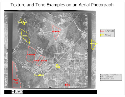
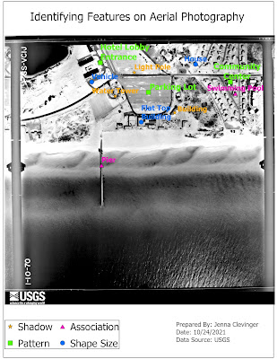
Start of a new GIS Course: GIS 4035 Photo Interpretation and Remote Sensing. This first lab we created 2 maps, the top one showing examples of textures, tones, and the bottom map shows examples of features that can be interpreted by shape or size, shawdow, pattern an association in aerial photos given to us. Seeing how features look on photos can help interpret them to what they are showing. This can be seen in the homes, buildings, swimming pools, piers and even parking lots I chose. They all have distinct characteristics as we have learned this lab that define their identity. Great first introduction assignment executed well!
Saturday, October 16, 2021
Final Project
Final Project Time!! Can you believe it?! I barely can. This intro class has flown by and what a whirlwind it was. I cannot say that there were times I did not panic. There was some panic, however this final project really wrapped up everything I have learned this class so far. This final project is about a transmission power line being constructed in Manatee and Sarasota Counties, as part of the southwestern portion of Florida. What does that entail you might ask...for this we focused on some objectives that the project faced: conservation lands imposed, wetlands, homes, schools, and the length of the line itself by using a few of the tools ArcGIS has to offer we have learned about so far. The following links are to a transcript and PowerPoint presentation on these objectives and how I analyzed them with my Padawan GIS map making skills. So, select by attributes, intersect those tools and let's get this final party started!
https://drive.google.com/file/d/1EVZdV5iTOwnP6RinUAx07ztFEIBUKMye/view?usp=sharing
https://docs.google.com/presentation/d/1--VBJb-exNc-s11kKzfvIXBQKBFGfS-f/edit?usp=sharing&ouid=117785791016538423035&rtpof=true&sd=true
Thursday, October 7, 2021
This week's lab was about Georeferencing, which is basically adding points to known objects like buildings and street corners in a raster layer to merge them to your map. Do it well enough and the RMS error can be minimal as I learned. The map above I created is of UWF campus, located in Florida with 3 rasters and a eagles nest location off to the right. Online learning is difficult I would say, because there are so many ways to layout a map and I am struggling with confidence in my layouts. If it was easy, everyone would be doing it though, so I am not giving up and hoping feedback will keep my head above water.
Saturday, October 2, 2021
This week I was introduced to Geocoding, where I was tasked to download data from the Dept of Education and the US Census Bureau Geography Program websites, set up an address locator and geocode the addresses. The result was a map with Manatee County, FL outlined and all the schools shown as points. What sounds as a simple task quickly decended into Excel spreadsheets, inserting tables into ArcGIS Pro and making sure all the schools had actual X, and Y location points. Although time consuming, it was pretty straight forward. It can be viewed following the link to ArcGIS Online web map: https://arcg.is/1XyDTn
Looking forward to what is next!
Subscribe to:
Comments (Atom)
GIS Portfolio
The final assignment in the GIS Certificate Program was to create a GIS Portfolio. It went as I expected. It is hard to write about yourself...
-
I am fan of color! This is my jam, I mean lab. This week we were introduced to isarithmic maps, which are two-dimensional representations of...
-
This week we dove into the deep end of trying to find features based on feature descriptions or clues in pixel data given to us. By using wh...
-
This week we were given a .las LiDAR file with data from the Big Meadows area of the Shenandoah National Park in Virginia. We learned how to...


